Liao et al. (2020) analyzed the changes in land use in the Yellow River Basin from 1980 to 2015. Their results show that,since the beginning of the 21st century, most land use changes in the Yellow River basin took place in the middle and east regions of the basin. Urbanised land took an evident increase by 44.32%. Grassland, arid land and forests are the main types of land use in the Yellow River basin, of which the former two decreased by 1.6% and 1.23% respectively, while forests increased by 2.53%.
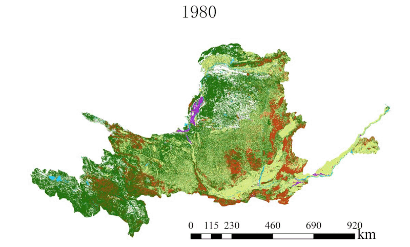
Urbanised land Arid land Unused Forests Water body Paddy field Grass land
Although the reasons behind land use changes are complex and diverse (Jia et al. 2007), Liao et al. (2020) think that the contribution from population change and socio-economic development to such changes cannot be ignored.
The increase of urbanised land and forests is closely related to China’s economic development and afforestation activities in the basin. Soil and water conservation measures such as afforestation have well reduced soil erosion and hence sedimentation, and played a positive role in the ecological conservation and high-quality development of the Yellow River (Hu et al. 2020). In its future economic development, it is necessary to continue the efforts in soil conservation and ecological rehabilitation, which, of course, are hinged on proper policy implementation. These would form the foundation for the rational and sustainable development of resources in the Yellow River Basin.
Full paper
- Liao Hui, Shu Zhangkang, Jin Junliang, Yang Chuanguo, Wang Guoqin. Study on the characteristics and driving forces of land use change in the Yellow River basin from 1980 to 2015. South-to-North Water Transfers and Water Science & Technology. http://kns.cnki.net/kcms/detail/13.1430.TV.20200520.1 (in Chinese with English abstract)
Zhang et al (2020) studied the runoff records of Chinese rivers in the past 62 years (1956 to 2018). Their analysis shows that almost all major rivers of China are in a state of decline in terms of runoff. Rivers of Northern China (the Yellow and rivers to its north) are declining more significantly. The Yellow, the Haihe and the Liaohe, compared to their runoff in the 1980s, have witnessed a decline in runoff of more than a quarter. The Haihe River is leading the league by a decrease of more than 80%.
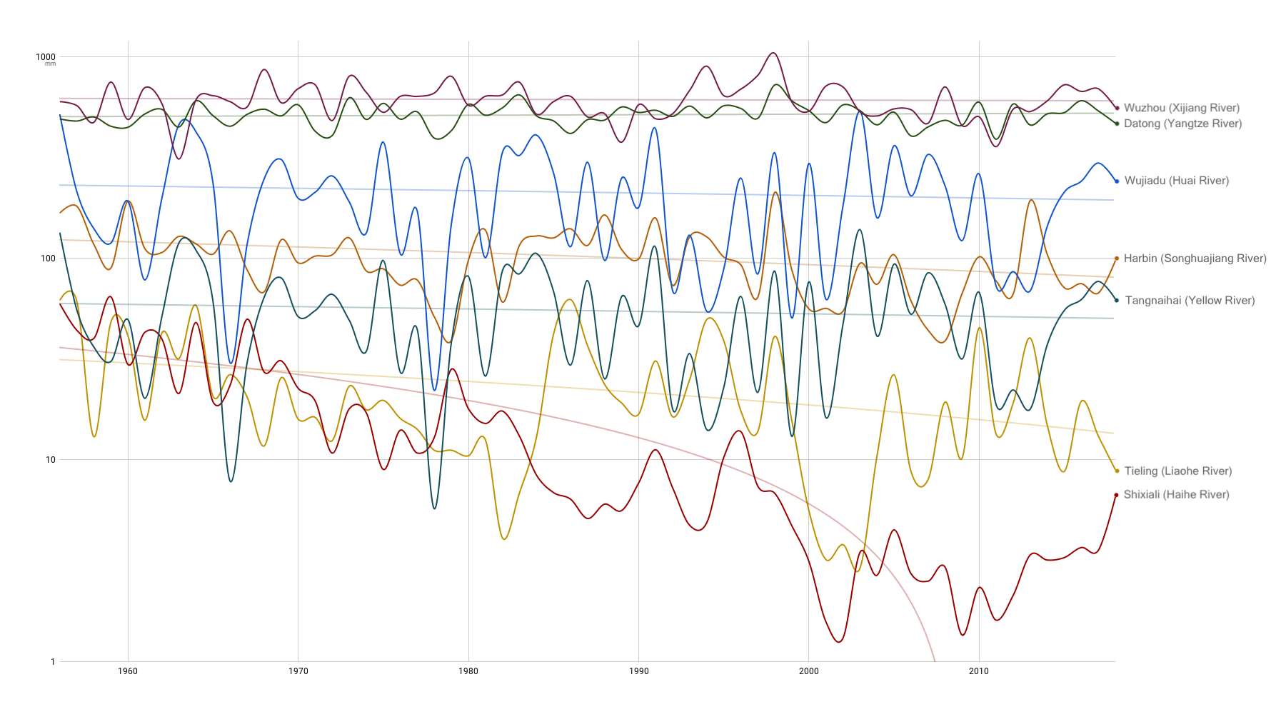
Under global warming, such changes might fit into the “dry places getting drier” paradigm (yet many scientists believe this paradigm over-simplifies the complexity of climate change impacts, for example, see Byrne et al. 2015, Feng et al. 2016), but river runoff decline in Norther China could be the result of the combination of multiple drivers. Apart from regional climate change, human interference impacts surface water significantly too. The authors therefore ague that “scientifically identifying the impacts from different drivers on river runoff is crucial to regional water management”.
Scientifically identifying the impacts from different drivers on river runoff is crucial to regional water management
Zhang et al 2020
Among the most developed three economic clusters of China, only the Bohai Bay rim, with Beijing, Tianjin and Hebei at its core, is located in semi-humid or semi-arid regions. The decline in surface water availability means this economically significant cluster is becoming more reliant on other sources of water, such as groundwater or cross-basin diversion. This would further exacerbate the conflict between different water uses such as for human consumption and environmental functions, which would pose an even greater challenge for China’s technical and institutional capacities in managing its water.
Full paper
- ZHANG Jianyun, WANG Guoqing, JIN Junliang, HE Ruimin, LIU Cuishan. Evolution and variation characteristics of the recorded runoff for the major rivers in China during 1956—2018. Advances in Water Science, 2020, 31(2): 153-161. http://journal16.magtechjournal.com/Jweb_skxjz/CN/Y2020/V31/I2/153 [in Chinese with English abstract]